


Kuwait. Series K6614. Edition 1-DMA (6), 2-NIMA (2), 3-NIMA (1).
Colour-printed map in 9 sheets, 1280 x 2220 mm. Scale 1:100,000.
€ 4,500.00
Classified map of Kuwait detailing international borders with Saudi Arabia and Iraq, prepared for military use by the US National Imagery and Mapping Agency; marked "for official use only". Nine adjoining sheets forming a large map showing the state of Kuwait in its entirety, though originating from three different editions of the same map series produced from the 1990s to the early 2000s. The map exhibits a wealth of information specifically relevant to both nautical and air operations in Kuwait, indicating landing fields, runways, radio transmitting stations, heliports, ports, piers and hydrographical data along with detailed plans of populated places such as Kuwait City, Al Jahra and Ahmadi, industrial complexes, government and commercial buildings, roads and railroads, places of worship, hospitals, schools, prisons, recreational areas, wells, mines, pipelines, oil and gas platforms as well as oilfields, indicating, among others, Ahmadi, Burgan, Al Maqwa and al Manaqish.
In very good condition.
Related
-

Kuwait. Series K961. Edition 5-NIMA, Al-Ahmadi.U.S. Government, 1998.
€ 3,000.00 -
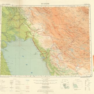
Asia 1:1,000,000. Bushire. Sheet North H-39.London, 1918.
€ 950.00 -
US Army Air Forces. Long Range Navigation Chart. Arabia, Restricted.Washington, D.C., 1944.
€ 2,500.00 -

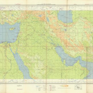
Southwestern Asia, Series K502.Washington DC, 1956-1961.
€ 3,500.00
