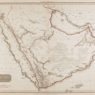
Road map of the United Arab Emirates
Road Map United Arab Emirates.
London, Hunting Surveys Ltd. / Automobile and Touring Club, [ca. 1981].
Colour-printed map, 590 x 840 mm. Scale 1:1,130,000. In English and Arabic.
€ 1,800.00
Road map of the United Arab Emirates, Qatar and Bahrain, including portions of Saudi Arabia and Oman. Apart from primary and secondary roads, proposed roads and roads under construction, the map indicates major cities such as Al Manamah, Doha, Abu Dhabi, Dubai, Sharjah, Umm Al Qaiwain, Ras Al-Khaimah, Al-Fujairah and Muscat. Includes airports, wadis, wells, pipelines, oilfields, mountain peaks, sand and gravel plains dunes, areas of silt, and sabkhas. With a general map of the Middle East and a list of points of interest in the Emirates on the reverse.
Condition
In excellent condition.
References
OCLC 8113094.
![Arabia and the Persian Gulf. N.W. Section, S.W. Section. [Map of Arabia and the Persian Gulf with additions and corrections to 1916].](https://inlibris.com/wp-content/uploads/2021/11/img-bn51281-324x324.jpg)