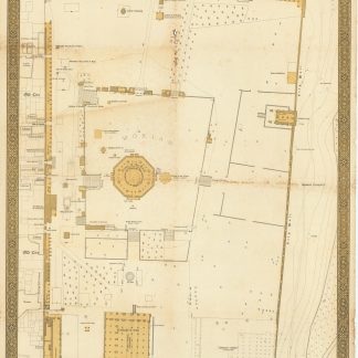
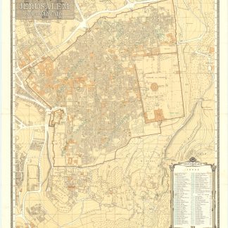
1930s plan of Jerusalem's Old City, reissued in 1967 after the Six-Day War
Jerusalem. The Old City.
Sepia toned pictographic folding map, 800 x 630 mm. Scale 1:2,500.
€ 800.00
A finely drawn, detailed plan of Jerusalem's Old City, originally produced by the British surveyor F. J. Salmon and here re-issued by the Survey of Israel, in the wake of the 1967 Six-Day War, when East Jerusalem including the Old City came under Israeli occupation.
Notable sites are identified, with particular emphasis on the Temple Mount. The Dome of the Rock and Solomon's Stables (now the El-Marwani Mosque) are labeled, among other sites. 63 sites throughout are numerically labeled and correspond with an index at lower right. Outside the Old City, King David's Tomb and the Church of the Dormition appear on Mount Zion. Several hospitals, schools, and cemeteries are also identified.
This map was originally compiled, drawn, and printed in British Mandate Palestine under the direction of F. J. Salmon (1882-1964), the Commissioner for Lands and Surveys, in 1936. Further editions were published in 1945 and 1947, including revisions with new information supplied by the government's Department of Antiquities. After Israel captured East Jerusalem in the Six-Day War in 1967, the Survey of Israel republished the map in both English and Hebrew in 1967 and 1970. These later editions are quite rare in either language.
Occasional very slight foxing, but generally in fine condition.