
Scarce first geological study of the Union
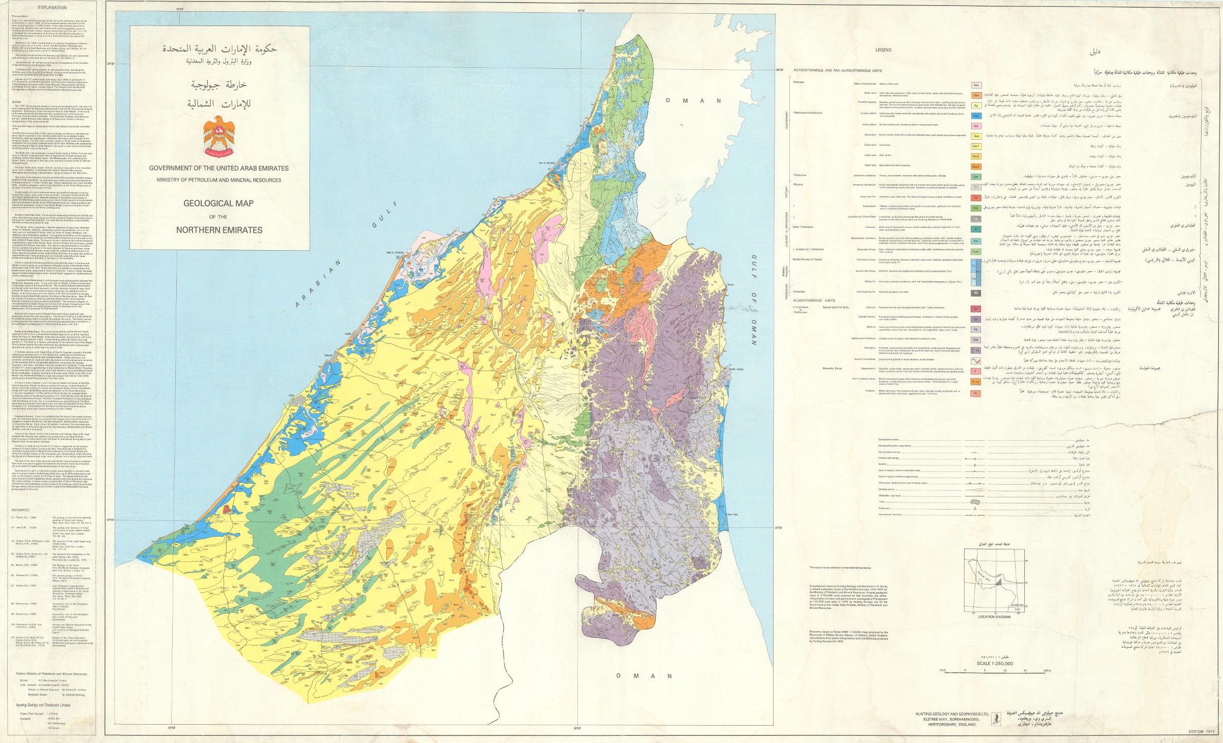
Government of the United Arab Emirates. Ministry of Petroleum and Mineral resources. Geological map of the Northern Emirates.
Colour-printed map, 720 x 1215 mm. Scale 1:250,000.
€ 6,000.00
The first geological map of the UAE to be published after the founding of the Union. Scarce, with only two copies listed in institutions worldwide, both in the UK at the Natural History Museum and the British Geological Survey, respectively; the copy at the Natural History Museum was stamped "CONFIDENTIAL - NOT TO BE MADE AVAILABLE TO THE GENERAL PUBLIC." Based on a detailed aerial photographic survey of the Emirates compiled and drawn by Hunting Geology and Geophysics Ltd. during a mineral exploration survey of the Northern Emirates in 1975-76, directed by the UAE's Ministry of Petroleum and Mineral Resources.
Hunting Geology and Geophysics (also styled Hunting Surveys) was an aerial surveying company based out of England and active throughout much of the 20th century; the company used their fleet of specialized aircraft to produce many early aerial photographs of the newly unified UAE, which were in turn drawn up as maps with special focus on geological formations and the natural resources of the new nation. Hunting's mid-1970s work records the earliest years of the Union during a time when mapping via aerial photography was an important task with relevance for geological studies, natural resource prospecting, and border disputes with Oman and Saudi Arabia - although this map includes the careful disclaimer that it is "not an authority on international boundaries." Captions and key bilingual in Arabic and English, and featuring a thorough explanatory essay in English along the left margin.
Expertly rebacked and reinforced, with faint creasing. A benchmark study in the geology of the Emirates, rare and in quite good condition.
OCLC 182962252.
Related
-
![Geographic Map of the Central Persian Gulf Quadrangle Kingdom of Saudi Arabia. Miscellaneous Geologic Investigations Map I-209 A [and] B.](https://inlibris.com/wp-content/uploads/2020/05/img-bn49619-324x324.jpg)
Geographic Map of the Central Persian Gulf Quadrangle Kingdom of Saudi …Washington, D.C., 1959-1961 CE = 1378-1380 H.
€ 9,500.00 -

Carte de l’Empire Ottoman comprenant les possessions de la Porte en Europe, …Paris, 1825.
€ 3,000.00 -
![Arabia and the Persian Gulf. N.W. Section, S.W. Section. [Map of Arabia and the Persian Gulf with additions and corrections to 1916].](https://inlibris.com/wp-content/uploads/2021/11/img-bn51281-324x324.jpg)
Arabia and the Persian Gulf. N.W. Section, S.W. Section. [Map of Arabia …Dehra Dun, 1916.
€ 8,500.00 -
Trucial States, Muscat and Oman. Wadi Al Jizi. Series K668. Edition I-GSGS. …United Kingdom, 1967.
€ 2,000.00