![Milchemet Jom HaKippurim [Yom Kippur War].](https://inlibris.com/wp-content/uploads/2024/05/img-bn63513.jpg)
![Milchemet Jom HaKippurim [Yom Kippur War]. - Image 2](https://inlibris.com/wp-content/uploads/2024/05/img-bn63513-a.jpg)
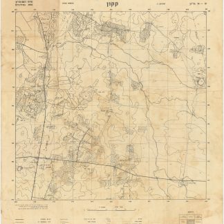
Milchemet Jom HaKippurim [Yom Kippur War].
8 original colour printed maps (80 x 145 - 165 x 239 mm) on a single sheet (465 x 655 mm).
€ 750.00
Rare educational mapping of the Yom Kippur War, fought from 6 to 25 October 1973, between Israel and a coalition of Arab states led by Egypt and Syria. It shows attacks on the Israeli occupied territories in Suez and the Golan Heights, as well as the situation after the 1974 disengagement agreements as a result of shuttle diplomacy conducted by Henry Kissinger.
The Yom Kippur War was the bloodiest military confrontation between Israel and its Arab neighbours, totalling nearly 53,500 casualties on all sides. Egypt's initial objective was to seize a foothold on the eastern bank of the Suez Canal and subsequently leverage these gains to negotiate the return of the rest of the Israeli-occupied Sinai Peninsula.
With the text of the military disengagement agreements of 18 January 1974 and 31 May 1974 printed on the reverse. The former, commonly known as Sinai I, had the official name of "Sinai Separation of Forces Agreement". Under its terms, Israel agreed to withdraw its forces from the areas west of Suez Canal, which it had occupied since the end of hostilities. Israeli forces were also withdrawn on the length of the whole front to create security zones, each roughly ten kilometres wide, for Egypt, UN forces, and Israel. Thus, Israel gave up its advances reaching beyond the Suez canal, but still held nearly all of Sinai. On the Syrian front, skirmishes and artillery exchanges continued. Kissinger's diplomacy eventually produced a disengagement agreement on 31 May 1974, based on exchange of prisoners of war, Israeli withdrawal to the Purple Line, and the establishment of a UN buffer zone.
In excellent condition.
OCLC 233457683.
![Milchemet Jom HaKippurim [Yom Kippur War].](https://inlibris.com/wp-content/uploads/2024/05/img-bn63513-324x324.jpg)