![Dawlat al-Imarat al-'Araabiyah al-Muttahidah [United Arab Emirates].](https://inlibris.com/wp-content/uploads/2025/03/img-bn65617.jpg)
![Dawlat al-Imarat al-'Araabiyah al-Muttahidah [United Arab Emirates]. - Image 2](https://inlibris.com/wp-content/uploads/2025/03/img-bn65617-b.jpg)
![Dawlat al-Imarat al-'Araabiyah al-Muttahidah [United Arab Emirates]. - Image 3](https://inlibris.com/wp-content/uploads/2025/03/img-bn65617-a.jpg)
![Dawlat al-Imarat al-'Araabiyah al-Muttahidah [United Arab Emirates]. - Image 4](https://inlibris.com/wp-content/uploads/2025/03/img-bn65617-c.jpg)
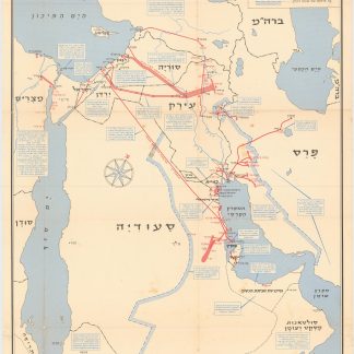
The earliest highway system and oil fields
Dawlat al-Imarat al-'Araabiyah al-Muttahidah [United Arab Emirates].
Colour-printed map, 790 x 1181 mm. Scale 1:750,000. In Arabic. Folded in original printed cover, 249 x 179 mm.
€ 25,000.00
The first and hitherto most detailed map of the newly-formed United Arab Emirates, showing the undefined border with Saudi Arabia and the early border with Oman, each later to be contested, and featuring the earliest highway system and oil fields and pipelines. In the Gulf, all UAE pearling fields are highlighted in pink. Also marked are the crucial seaports at Abu Dhabi, Dubai, Sharjah, and Ras Al Khaimah, and the Liwa villages, the ancestral homeland of the Al Nahyan royal family of Abu Dhabi. Includes a table of oil production through 1972 and a small inset map of the concessions of oil companies, including Pan Ocean, Middle East, Abu Dhabi, Philips, and Bandaq Oil Companies, Dubai Petroleum Company, and Abu Dhabi Marine Areas. An English version of the same map appeared in the same year.
While the English version of Morsi's map is recorded in 11 copies, OCLC locates only two copies copy of the present Arabic issue (Duke and Exeter University). Another more common, reduced-format version of the same was published the following year, in 1974.
A fantastic record of a newly-born country and the state of its infrastructure and oil industry at the time of unification.
Original folder bears a stamp in Arabic mentioning that the border amendments with the KSA from 1974 "do not appear on this map, which was prepared in 1973". In excellent condition.
OCLC 1088534308.
Related
-
![[Al-Khalij al-'Arabi]. Arabian Gulf Magazine. Volume 1.](https://inlibris.com/wp-content/uploads/2024/02/img-bn61387-324x324.jpg)
[Al-Khalij al-'Arabi]. Arabian Gulf Magazine. Volume 1.University of Basrah, 1973.
€ 350.00 -
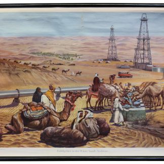
Erdölgebiet in der Wüste Saudi-Arabiens.Kempen, ca. 1950s.
€ 2,500.00 -
![Dawlat al-Imarat al-'Araabiyah al-Muttahidah [United Arab Emirates].](https://inlibris.com/wp-content/uploads/2025/02/img-bn65618-324x324.jpg)
Dawlat al-Imarat al-'Araabiyah al-Muttahidah [United Arab Emirates].London & Abu Dhabi, 1974.
€ 9,500.00 -
Neft ba-mizrah ha-tikhon. Zikaynot, shadot, tzinorot, batei zikuk. (Oil …Tel Aviv, 1957.
€ 5,000.00
![Dawlat al-Imarat al-'Araabiyah al-Muttahidah [United Arab Emirates].](https://inlibris.com/wp-content/uploads/2025/03/img-bn65617-324x324.jpg)